Friday, October 20, 2006
I have used the Adventure Cycling Association (ACA) maps to ride a few thousand miles over recent years. The maps are great. I found myself frustrated occasionally though, because I had to watch them so closely, and sometimes road/street signs were missing, or had names different from the maps. And, of course there were times when I wanted to venture to a town not on the map, requiring that I carry a highway map anyhow.
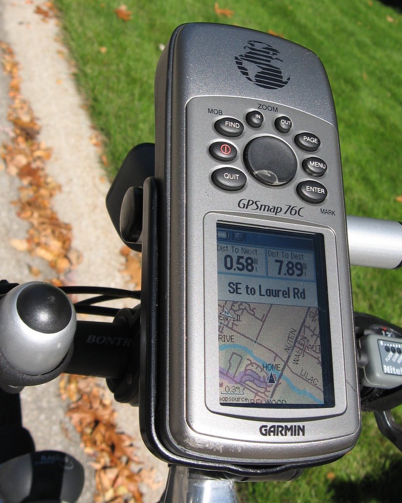
Last year, I decided to get a Global Positioning System. After a lot of research on the web, shopping a bit at local sporting goods stores, and questions on the ACA GPS Forum, I bought a Garmin GPSmap 76C, a handlebar mount, and a set of electronic street maps for North America. I also got a dashboard mount so I could use it in my car. I use my unit on my road bike and in my car, but you may be interested in using it for mountain biking, hiking, hunting, fishing, boating, or geocaching. You can buy specialized electronic maps for those purposes.
As you probably know, GPS works by communicating with a set of satellites. The GPS can pinpoint your latitude and longitude to within a few feet. It then overlays that location on an electronic map, and displays it on a screen. Viola, it knows where you are, even if you don’t.
How a GPS Works
Well, I don’t know how it works. But I know how to use it. There are three main features we need to understand. Waypoints, Routes, and Find are Garmin terminology. Other brands may use different terminology, but I feel certain that the functionality is the same.
1. Waypoints (also known as Viapoints). These are usually special intersections: for example where you need to make a turn or where the road name changes. You can download them from the ACA routes website. You can also make your own Waypoints if you want, for example make a Waypoint of the lodging or town where you are staying at night.
2. Routes. This shows you how to get from one location to another. Often, it tells you how to get from one Waypoint to another. Your GPS figures out the route with its tiny brain. You can tell it to simply go to a single destination Waypoint, or you can tell it to go there via a series of Waypoints. When you download a route from the ACA website, it routes you through a series of waypoints, insuring that you take bicycle friendly roads and streets.
3. Find. The unit has a find button: you can key in the name of a town for example, and then hit the goto button. The unit will now plan a route from your current location to the town. The map also includes a ‘yellow pages’ so you can find various attractions, and it has street names and numbers so you can find addresses. The other thing you can find is waypoints as mentioned above.
I’ll never again tour without my GPS
There is a lot to like about a GPS. I recently completed a coast to coast expedition on the ACA Northern Tier route: some 4,500 miles. I only got really lost twice. On one occasion the problem was that I didn’t trust my GPS. It kept telling me to make a u-turn. I thought it was confused because I was on a gravel road and I had programmed the unit to avoid unpaved roads. By the time I realized that it was smarter than me, I was off the ACA map and had gone about five miles out of my way. Not a big problem; I did a find on that night’s campground and hit the goto button, whereupon it calculated a new route for me. On the other occasion I was in Moorhead, MN. Nearly every street is a ‘street’ or an ‘avenue’, and they use numbers extensively. I did a find and goto on 4396 28th St SW, when I should have used 4396 28th Ave SW to find a KOA campground. When I got to where I said I wanted to go, I found only a few houses. I knocked on a door and asked where the campground was: the local said “Oh – you want 28th Ave”.
It actually has taken me several hundred miles to know all the idiosyncrasies of my unit. If you get one, expect to get better at using it as you gain experience. You’ll learn when to trust the unit and when to second guess it: more on that later.
On a typical day, you select the route for that day, hit the navigate button and follow the route and prompts which display on the screen. It tells you how far you have gone, how far to the next turn, and how far to that night’s lodging. It can also tell you the elevation, time of day, speed, sunrise and sunset times, and a host of other information. I keep an eye on the paper ACA map as well as the GPS screen. The paper map is good because it gives you a ‘big picture’ of your trip and lets you verify that the GPS’s brain is not confused. I frequently turned my GPS off, especially in eastern Montana and North Dakota, where I rode for mile after mile without making any turns or going through any towns.
The find and goto are really powerful. I frequently used them to find a library, bike shop, or post office. The ACA maps tell you which towns have these attractions. Once a day or so, when I got to a town with a library, I would frequently find the nearest library and simply goto it! We spent three days in the Niagara Falls area. There were a lot of things to see and do there. I used the find and goto to great advantage.
Some days, you may want to take a shortcut. The GPS is great for this. You find your final destination, hit goto, and it calculates the shortest route for you, ignoring all the ACA Waypoints in between. I did that sometimes, comparing the shortcut distance to the ACA route distance before deciding which way to go. Just bear in mind, that the GPS doesn’t know the bicycle friendliness of the shortcut.
The technology is not perfect.
If you have used one of the mapping sites on the internet, you have surely noticed that the maps aren’t always right. If you have used the ’yellow pages’ you will also have noticed some shortcomings. The GPS shares these shortcomings. For example, you may be trying to find a restaurant that is not on the map and that is not one of the waypoints you downloaded from ACA. You’re out of luck. Similarly, you may be looking for an address, but the street name on the electronic map is not the same as the name you are searching for. Maybe you are looking for US20 when you should be looking for Main St. Another problem occurs when you are not sure what town a place is in. Perhaps you think it is in Fargo, but it is really in a suburb of Fargo. Again, you’re out of luck. If you can’t tell the GPS exactly where to go, it is of no value. That’s where you stop and ask a local for directions.
One of the more frustrating things is when the map has the wrong road surface. It is common for a gravel road to be identified as paved. When you hit the goto button, you can set the GPS to avoid unpaved roads, but it can only act on the data provided by the electronic map. If you’re in a state with a lot of gravel roads, be leery of venturing far off the ACA routes.
Bike paths are not on the electronic map. If the ACA route departs from mapped streets, you simply need to follow the paper map, not the GPS. If you are venturing off the ACA route, remember that the GPS doesn’t know if a road has nice wide shoulders or no shoulders. Nor does it know if traffic is heavy or light.
Although my unit was waterproof, I found that I needed to keep it in a zip-lock bag when there was a lot of rain. In Washington, it rained every day for a week. After about 2 days in the rain, the unit started doing weird things, so I started keeping it dry and it was fine.
Bear these shortcomings in mind. Also bear in mind that, to really enjoy your GPS and get the most out of it, you need to be something of a geek. That is to say, you need to like gadgets.
Pre planning.
These comments are specifically for the:
• Garmin GPSmap 76C - the GPS unit that mounts on my handlebar,
• City Select North America - the electronic map on a CD that I loaded onto my desktop PC, and then downloaded to the GPS unit
• Garmin MapSource – PC Desktop mapping software that lets you manage everything. For example it will help you
o Make routes and waypoints
o Download routes and waypoints from the ACA
o Transfer all this to the GPS unit.
When I bought my system, I got all three as a bundle, along with a USB cable to transfer data from my PC to my GPS unit. I think all high-end GPS units have similar functionality, although some small low-end and older units do not have the electronic map.
Basically, there are four planning steps after you get the City Select map and MapSource software loaded into your PC.
• You set routing parameters. Tell MapSource you are routing for a bicycle, to avoid car pool lanes, toll roads, and unpaved roads. Also favor minor roads and use the shortest distance.
• Second, you download routes and waypoints from the ACA website into a file on your PC. This data is free right now, but I can see this being a source of revenue as GPS technology improves. The ACA has excellent documentation to help you. Then you open this routes/waypoints file with MapSource. Once you have it open, save it under a new name so you don’t accidentally overwrite the file you downloaded from ACA.
• Third, you manually make your own waypoints. For example if on day-1 you are going to go from Anacortes to Concrete, you would make an overnight waypoint for each city. Repeat this for each overnight on the entire trip. When you make and save a waypoint you give it a name. I named mine with the name of the nearest town, which makes them easy to find.
• Fourth, you split up the big route you downloaded from ACA into small routes – one for each day. Each route will start and end at one of the overnight waypoints you created up in step three. Be sure to read the instructions on the ACA website: it has a good copy/paste procedure to make this a fairly painless process. When you create and save a Route, you give it a name. I named my routes “Day-01, Day-02 etc., which makes it easy to keep them in order.
My unit was limited to 1,000 waypoints and 50 routes, so I had to split the entire Northern Tier into two sections, east and west. In the beginning I loaded just the western half, and in Michigan, I was able to load the eastern half of the trip. Some of the newer units have larger memories and removable memory cards, so if you plan to do long trips, keep that in mind when you make your buying decision.
Remember to keep a spare set of batteries handy. My unit gave me plenty of advance warning, so I never got a blank screen unexpectedly.
If you don’t like getting lost, you like the flexibility of venturing off the ACA routes, and you enjoy doing some pre-planning, I think you will enjoy using a GPS for your next bike trip.
Nuts and Bolts
Cost.
My bundle (which is currently discontinued), cost me a bit under $600. You can expect to pay as little as $100 for a GPS, but it won’t have all the features I have described. Units are getting more powerful and less expensive as the technology improves and the market grows.
More Information
To get more information, you can search for ‘Bicycle GPS’ on the web. That can take you to manufacturers and vendors. Garmin and Magellan are the best known manufacturers, but product selection is increasing regularly.
Before you buy your unit, be sure to study the ACA web site. Not only is this the source of biking routes to download, it is also an excellent source of information, and advice.
Take a look at these pages:
- The ACA Home Page: http://www.adventurecycling.org/
- The ACA Forum, where you can ask questions and get answers: http://www.adventurecycling.org/forums/
- Where you get a ‘how to…’ on everything about loading ACA routes into your GPS, and more: http://www.adventurecycling.org/routes/gps.cfm
![]()
